
Okanagan Groundwater (click to enlarge)
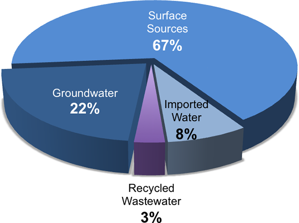
67% of the water used in the Okanagan BasinLand area from which water drains towards a common pointThe Okanagan watershedLand area from which water drains towards a common point, or basinLand area from which water drains towards a common point, is a narrow strip that spans from Armstrong, British Columbia, Canada to the US border and includes five main lakes – Okanagan, Kalamalka-Wood, Skaha, Vaseux and Osoyoos – and surrounding mountains.
The Okanagan BasinLand area from which water drains towards a common point includes all the land that feeds water to our big lakes, and is almost 200 km in length and 8,000 km2 in area. Kelowna, Vernon, Penticton and Osoyoos all lie within the Okanagan BasinLand area from which water drains towards a common point. is derived from surface sources (lakes and streams), and 22% is derived from groundwaterWater existing below the ground surface in aquifers, which is currently unlicensed.
The remaining 11% comes from recycling wastewater and by importing water across the basinLand area from which water drains towards a common point boundary from adjacent areas.
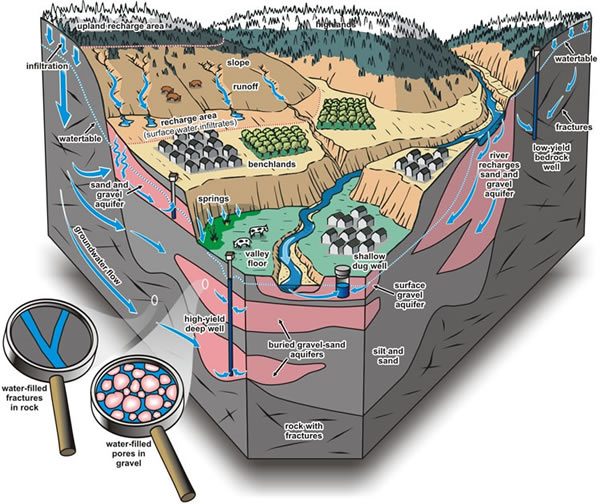
A “significant” portion of the surface waterWater that flows in streams and rivers, and exists in natural lakes, wetlands, and in reservoirsArtificial lakes used to store water in lakes and tributary streams is derived from groundwaterWater existing below the ground surface in aquifers.
Our knowledge of groundwaterWater existing below the ground surface in aquifers supply potential, aquiferAn underground formation that stores groundwater health, and the actual amount of groundwaterWater existing below the ground surface in aquifers being used is poor.
Significant further effort is needed to properly understand the groundwaterWater existing below the ground surface in aquifers resource and the volumes of water that are drawn from wells.

Total Water Use - by Source
More Key Findings: