The Okanagan BasinLand area from which water drains towards a common pointThe Okanagan watershedLand area from which water drains towards a common point, or basinLand area from which water drains towards a common point, is a narrow strip that spans from Armstrong, British Columbia, Canada to the US border and includes five main lakes – Okanagan, Kalamalka-Wood, Skaha, Vaseux and Osoyoos – and surrounding mountains.
The Okanagan BasinLand area from which water drains towards a common point includes all the land that feeds water to our big lakes, and is almost 200 km in length and 8,000 km2 in area. Kelowna, Vernon, Penticton and Osoyoos all lie within the Okanagan BasinLand area from which water drains towards a common point. Water Accounting Model (Accounting Model) brings all parts of the Project together and is used to create a water balanceThe flow of water in and out of a system. within the basinLand area from which water drains towards a common point.

Average Annual Water Balance for the Basin (click to enlarge)
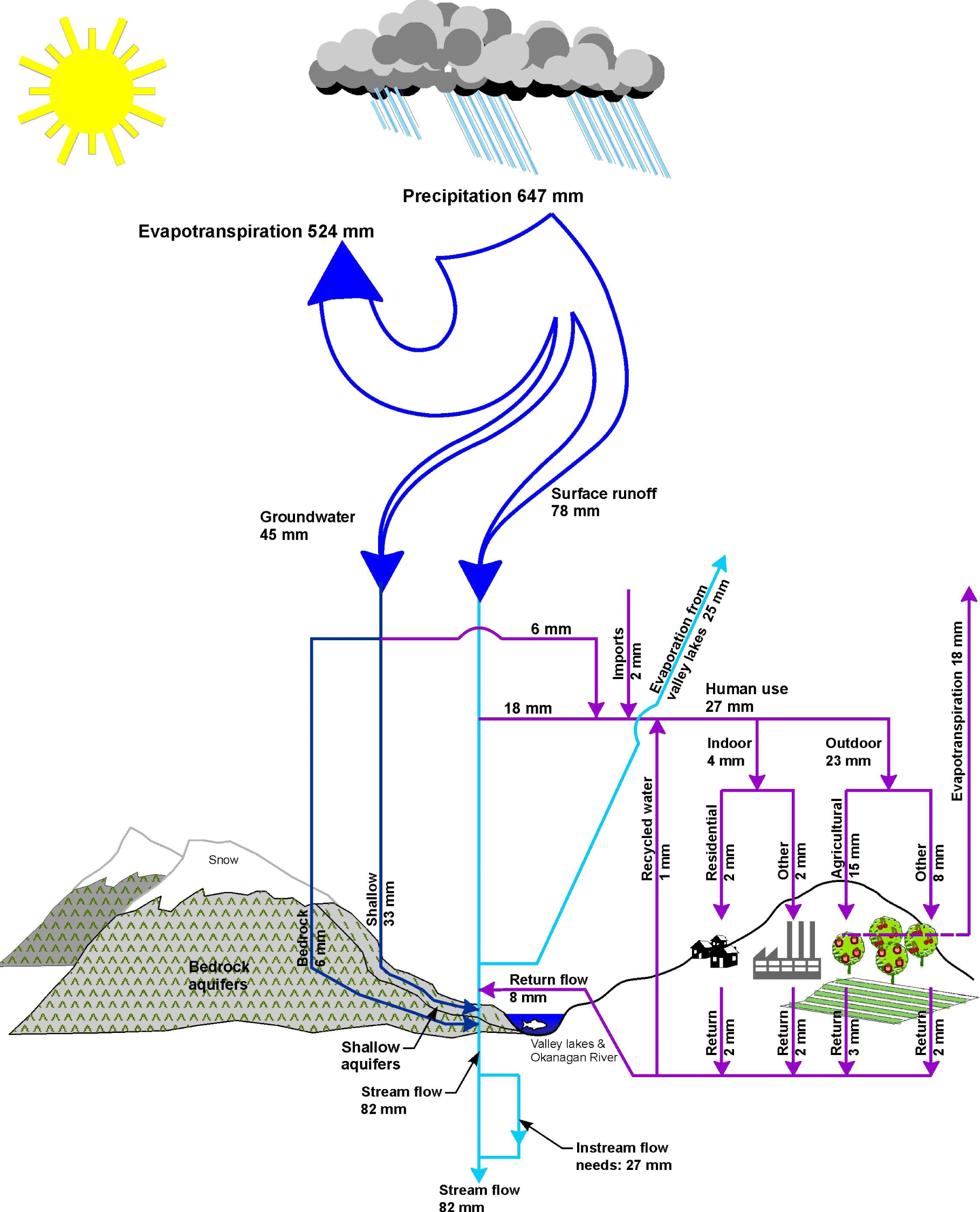
The model estimates the effects of reservoirAn artificial lake used to store water storage, return flows, and water withdrawals on natural streamflows, groundwaterWater existing below the ground surface in aquifers, and lake levels.
The model can be used to show how water management decisions can positively or negatively affect the entire basinLand area from which water drains towards a common point, or one part of the basinLand area from which water drains towards a common point, even if the water management activity is occurring in another part of the valley.
The Accounting Model can also help evaluate potential effects of climate change, population growth, water useVolume or rate of water diverted or withdrawn from a water body (eg a stream, lake, or groundwaterWater existing below the ground surface in aquifers aquiferAn underground formation that stores groundwater) for use by humans on the land surface. Actual water use is determined through direct measurement. Water demand is an estimate of actual water use. efficiency, agricultural land base expansion, and mountain pine beetle when it is used for future scenarios.
Project Downloads:
- Summary Report – Part Three – Models (468Kb PDF)
- Appendix J Okanagan BasinLand area from which water drains towards a common pointThe Okanagan watershedLand area from which water drains towards a common point, or basinLand area from which water drains towards a common point, is a narrow strip that spans from Armstrong, British Columbia, Canada to the US border and includes five main lakes – Okanagan, Kalamalka-Wood, Skaha, Vaseux and Osoyoos – and surrounding mountains.
The Okanagan BasinLand area from which water drains towards a common point includes all the land that feeds water to our big lakes, and is almost 200 km in length and 8,000 km2 in area. Kelowna, Vernon, Penticton and Osoyoos all lie within the Okanagan BasinLand area from which water drains towards a common point. Water Accounting Model (18.3Mb PDF)