Lake levels in the Okanagan are managed by the Government of B.C. using a series of dams and other structures located on major lakes and the Okanagan River between Penticton and Osoyoos. The system was constructed by the federal and provincial governments in the 1950s to control flooding and (secondarily) to provide water for irrigation. A comprehensive water study in the early 1970s led to the Okanagan Basin Agreement, which recommended target lake levels and river flows to achieve several other benefits in addition to flood control. Those recommendations formed the basis for the lake level operating plan that is still in use today.
It is becoming increasingly challenging to manage the level of Okanagan Lake because of the intensity and frequency of floods and droughts brought on by climate change. The worst flooding in living memory occurred in 2017, and the lake was near the lowest level in its written historical range in 2021. In addition, the dam infrastructure is reaching the end of its operational lifespan.
Improving the lake level regulation system will also provide an opportunity to reflect societal priorities and values that have changed since the 1950s. Environmental protection is much more important than it was half a century ago. While the lake level regulation system has provided significant benefits to society, its construction drastically altered the Okanagan River to a mostly straight and narrow engineered channel, significantly impacting natural river and floodplain processes. In addition, the system was designed and constructed without consultation with or the approval of the syilx people, and its impacts on syilx society have not been thoroughly documented. Indigenous rights and title must now be considered, and Indigenous leaders and technical staff must be included as equal partners in planning processes.
A 2021 report commissioned by the OBWB and the Government of B.C. provides a road map for modernizing Okanagan lake level management and the Okanagan Lake Regulation System (OLRS). The ‘Plan of Study’ report was developed through review of historical and recent scientific and engineering work, in consultation with an advisory group of federal, Indigenous, provincial, and local governments with responsibility for Okanagan water. The report calls for 17 studies to be completed over approximately 7 years to feed information into a final plan on how to proceed in a coordinated and well-thought-out manner.
Click to expand the studies below.
> Study 1: CREATE LINKED OKANAGAN-SIMILKAMEEN HYDROLOGIC MODEL (complete)
High streamflows in the Similkameen River can create backwater conditions that influence water levels in Osoyoos Lake. A single linked hydrologic model for the Okanagan and Similkameen River watersheds is needed to comprehensively model streamflows and water levels for the entire Okanagan Basin under the influence of future climate, and to examine future scenarios related to land cover and other changes.
> Study 2: IMPROVE OLRS OPERATING PLAN DOCUMENTATION
While an Operating Plan and water management guidelines are used to direct the operation of the lake level management system, judgments are also applied in real-time in response to changing circumstances and events and system limitations are not well documented. Improved documentation is needed to facilitate improvements in hydraulic modelling (Study 3), and to facilitate knowledge transfer between provincial operators and other parties.
> Study 3: CREATE INTEGRATED HYDRAULIC MODEL FOR OKANAGAN MAINSTEM
A hydraulic model that includes the entire Okanagan valley-bottom system from Ellison Lake downstream to Osoyoos Lake and across the US border to the confluence of the Okanogan and Similkameen rivers is needed before flood and drought risk assessments for all Okanagan valley-bottom areas can be completed.
> Study 4: IMPROVE LAKE INFLOW FORECASTING MODELS AND ACCOUNT FOR UNCERTAINTY
The B.C. River Forecast Centre (RFC) operates a suite of models to forecast inflows to the mainstem lakes each spring. Recommendations for model improvement have been made in previous studies, and the RFC is engaged in progressively improving the existing models and developing new models. Although there is uncertainty associated with the forecast models, a method of accounting for uncertainty in model output has not yet been incorporated into OLRS operations. Doing so has the potential to improve operational decision-making.
> Study 5: EXPAND GROUNDWATER KNOWLEDGE IN SUPPORT OF OLRS MANAGEMENT
The role of groundwater in the Okanagan hydrologic cycle is still relatively poorly understood. Knowledge improvements will promote better management of lake levels. In particular, the role of groundwater in influencing seasonal inflows to the major tributaries and the mainstem lakes is not yet well understood, nor is the influence of groundwater inflow to the Okanagan River downstream of Penticton, which influences tributary inflows and constrains the ability to release water from Okanagan Lake.
> Study 6: REFINE FISH WATER MANAGEMENT TOOL INPUT DATA AND MODEL
The Fish Water Management Tool (FWMT) is a decision support system used to inform lake level management. It is a hydrological and fisheries process model that provides information on spawning, incubation, and emergence timing to the operator, who uses this information in operational decision-making to manage the impacts of operations on fish in the mainstem Okanagan lakes and the Okanagan River. The model works well, however, more refined fisheries information and a correspondingly refined FWMT model will enable more informed OLRS operations and reduced risk to fish and the aquatic environment.
> Study 7: REFINE MAINSTEM LAKE BATHYMETRY (complete)
This is a stand-alone study that will inform future upgrades to a previously completed mainstem flood mapping project, and site-specific flood elevation analyses. Results will be useful to other studies within this Plan of Study, but none depend on its results. The updated lake bathymetry data will tie into a recently upgraded bathymetry dataset for the Okanagan River and support a future updated flood hazard assessment for the Okanagan mainstem lakes. Improved bathymetry data would have other uses as well, for example for navigation, water quality, and fisheries habitat studies.
> Study 8: STATE OF THE OKANAGAN MAINSTEM LAKES AND RIVER BEFORE EUROPEAN SETTLEMENT
Previous research and reports have referred to historical conditions in the Okanagan prior to the arrival of European settlers. However, this knowledge has not been assembled into a single location, nor has it been quantitatively documented or mapped at a sufficient level of detail to provide a sound basis for informing future decision-making related to the management of the Okanagan mainstem lakes and river system. This study will address that gap.
> Study 9: OLRS HISTORY, BENEFITS, AND RETROSPECTIVE IMPACT ASSESSMENT
The regulation system was constructed to control flooding, but is now operated to manage drought, and to consider the needs of fish and other aquatic organisms, and recreation. It has provided significant benefits to society; however, its construction drastically altered the Okanagan River from its natural form to a mostly straight and narrow engineered channel constrained by dikes, with several drop structures to replace the natural river gradient. In addition, the OLRS was designed and constructed without consultation with, or the approval of the syilx people. The benefits and the impacts of the OLRS should be comprehensively investigated and documented to inform the new Operating Plan.
> Study 10: FLOOD LEVEL IMPLICATIONS OF NOT CHANGING THE OLRS OPERATING PLAN (complete)
This study is intended as a supplementary study to the Okanagan Mainstem Floodplain Mapping Project, which assumed that modifications would be made to the lake level management system Operating Plan to mitigate the expected higher and more frequent floods in the future. Without the modifications, the design flood levels for the lakes would be higher. This study is needed to help the public and decision-makers understand the unmitigated impacts of climate change on design flood levels.
> Study 11: OKANAGAN MAINSTEM FLOOD RISK ASSESSMENT (complete)
This flood risk assessment builds on the flood hazard assessment completed in 2020 to identify where future flood mitigation action is warranted, and to identify, evaluate, and recommend flood mitigation options based on quantitative analysis of costs and benefits. The flood risk analysis considers impacts on constructed assets, such as buildings, roads, and water supply infrastructure. Impacts on natural ecosystems and other receptors will be considered in Study 13.
> Study 12: OKANAGAN MAINSTEM DROUGHT RISK ASSESSMENT
Although many water suppliers understand the risks related to low water levels and streamflows for their own water systems, no comprehensive valley-wide inventory of water supply assets exists, nor has there been a valley-wide analysis of the risks to water supply infrastructure and other assets susceptible to impacts associated with drought. The drought risk analysis will consider impacts on constructed assets, such as water supply infrastructure, marinas, and docks. Drought impacts on natural ecosystems and other receptors will be considered in Study 13.
> Study 13: IMPACTS OF CLIMATE CHANGE AND OPERATING PLAN CHANGES
Progressive changes in climate are changing the hydrologic regime that determines the rate, timing, and volume of water received by the mainstem lake and river system from higher elevation areas of the Okanagan Basin. These climate and hydrologic changes are predicted to continue for at least the next several decades, which means that the operational challenges experienced by the dam operators in some recent years will continue or worsen over time. Accordingly, the benefits provided by the lake regulation system (e.g., flood control, drought management, fisheries, and recreation) are expected to diminish over time. This study will examine the extent to which climate change will impact the ability of the regulation system to continue to provide the benefits described in Study 9. It will focus on natural aquatic and terrestrial ecosystems, socio-economic conditions, and international agreements.
> Study 14: OLRS LIFECYCLE ANALYSIS AND REPLACEMENT COST ANALYSIS
The lake regulation system assets include dams, control structures, drop structures, dikes, and drainage works. These assets were first constructed in the 1950s and have been managed and maintained by the Government of B.C. The condition of infrastructure is comprehensively evaluated at 10-year intervals, and necessary repair and maintenance work is completed. Each asset will reach the end of its useful service life over the next few decades and will need to be replaced or comprehensively rehabilitated. A present-day value for these assets, estimated cost of replacing them, and schedule for asset replacement should be developed in preparation for this.
> Study 15: OPPORTUNITIES TO RESTORE LOST OLRS BENEFITS
Recent operational experience indicates that the lake regulation system may no longer be fully capable of providing the benefits (flood control, drought management, fisheries, and recreational) that the system was designed to deliver. This study will examine the infrastructure changes that could contribute to restoring those lost benefits, including incorporating greater flexibility to accommodate future hydrologic changes related to ongoing climate change.
> Study 16: FEASIBILITY OF RE-NATURALIZING AND RESTORING THE MAINSTEM SYSTEM
The Okanagan River is now entirely confined within an engineered channel between Okanagan and Skaha lakes. It is also channelized from Skaha Lake to Vaseux Lake. Between Vaseux Lake and Osoyoos Lake the river is partly natural, but mostly channelized and confined by dikes. As a result of the lake regulation system, the river lost about half its original length in the section between Vaseux Lake and Osoyoos Lake, riparian and wetland areas were reduced by about 90%, and the average width of the river corridor is now 45 m, compared with 400 m before the regulation system was constructed.
It may now be desirable and feasible to re-naturalize and restore ecosystem function throughout the Okanagan mainstem system. This study will develop a plan for that, recognizing the need to avoid impairing the flood control, drought management, and other benefits that the regulation system has provided.
> Study 17: GOVERNING CONDITIONS FOR MODERNIZING THE OLRS
This study will identify and describe the current legal, political, cultural, environmental, and social contexts relevant to the process of modernizing the lake regulation system, and will anticipate future changes to these contexts, since they may evolve over a period of project implementation potentially spanning two or more decades.
> Study 18: DEVELOP A PLAN FOR MODERNIZING THE OLRS
This study will develop a comprehensive, climate-resilient plan for modernizing the lake regulation system that reflects the values and desires of all Okanagan society (Indigenous and non-Indigenous). The plan will likely include replacement and upgrades of infrastructure, changes to the Operating Plan, and potentially a project to re-naturalize and restore lost aquatic habitat and ecosystem function throughout the mainstem Okanagan valley. The plan produced in Study 18 will also provide the foundation for securing funding to complete the lake regulation system modernization project.
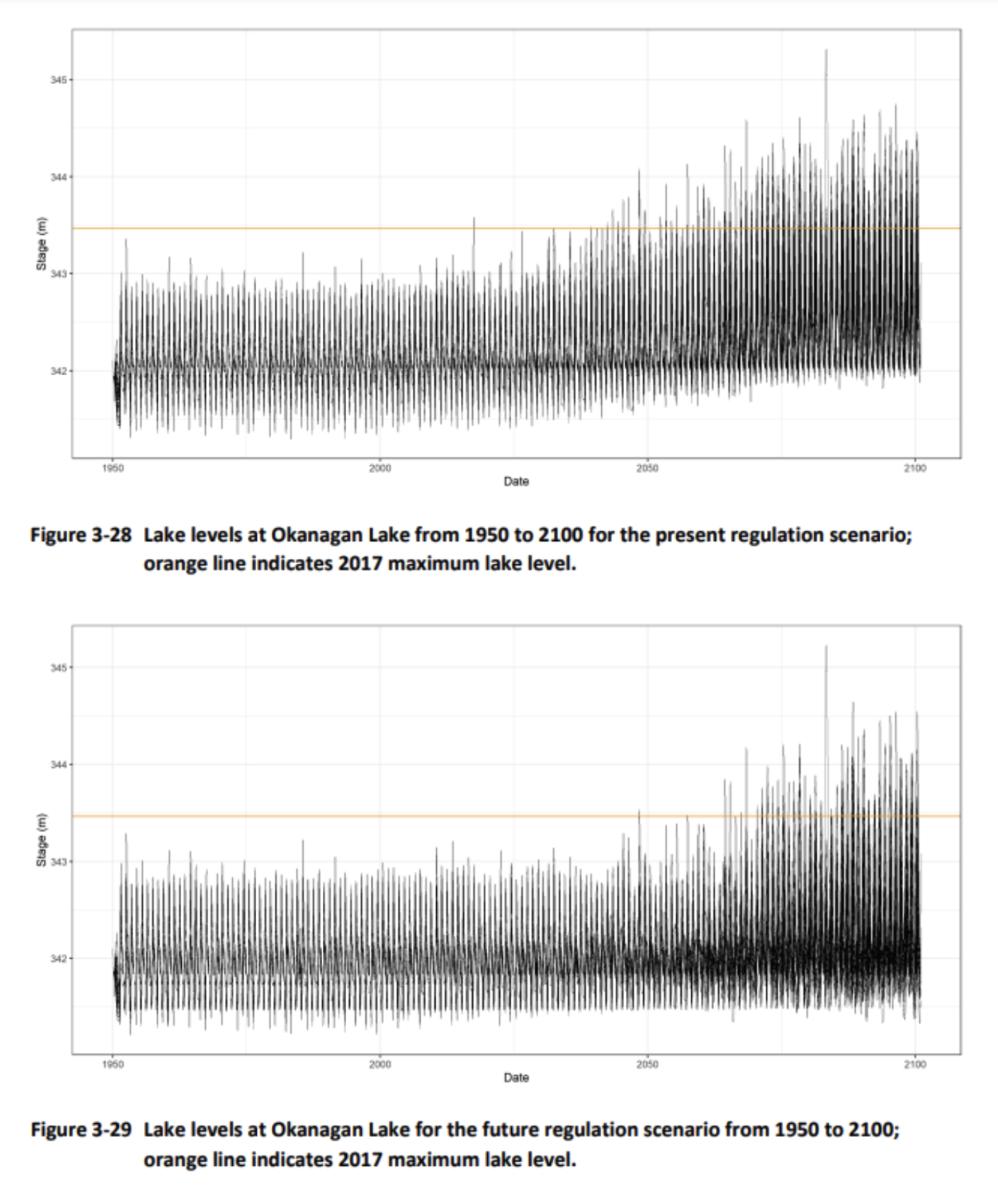
These figures show past and projected lake levels at Okanagan Lake under the current regulation system (top) and a possible modified regulation system (bottom). The 2017 flood event (orange line) appears to be a rare and extreme event in the historical record. However, the event becomes continually more common into the future. According to the model, a modified regulation system can help mitigate flooding from future high lake levels.